A better understanding of urban microclimates: a challenge to cope with climate change in cities
This article was originally published in L'Édition n°27.
Cities are complex environments, and we must pay particular attention to their climates. As both causes and victims of climate change, cities today face many challenges in preparing for the future. In order to help them, researchers at Université Paris-Saclay are working to better understand urban microclimates, the dynamics that drive them and the parameters that influence them such as vegetation and air pollution.
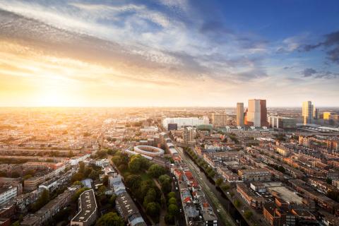
More than half of the world's population now lives in cities, i.e. places with a high density of both people and buildings. This figure will continue to rise over the coming decades, with the number of city dwellers set to almost double by 2050, with seven out of every ten people in the world living in urban areas.
While urban areas have a decisive impact on the production of greenhouse gases (GHGs) – accounting for 75% of global emissions responsible for climate change – they are also particularly sensitive to the effects of this change. As a result of human activity and the nature of urban pavements and buildings, these areas are subject to heavy pollution and increasingly frequent heat waves, which are having a major impact on the health of urban populations.
Heat waves, like those France suffered in 2003 or 2022, are associated with a marked increase in mortality, particularly among the most vulnerable and exposed populations. Air pollution by fine particles is responsible for 40,000 deaths a year in France. These public health issues mean it's essential that we have a better understanding of atmospheric phenomena in cities, all the more so in the context of climate change. We need to adapt urban environments to make them more habitable in a future that looks set to b efollowing an unavoidable trend of increasing temperatures.
The complex microclimates of cities
To understand the microclimate of cities, we first need to understand what's different about this environment. Sophie Bastin, researcher at the Atmospheric Space Observations Laboratory (Latmos- Univ. Paris-Saclay/National Centre for Scientific Research, CNRS/Université de Versailles Saint-Quentin-en-Yvelines, UVSQ/Sorbonne Univ.), explains: "The urban environment is unique in that its ground is impermeable. The water doesn't stay there as long, which alters the energy balance." This means that the energy that the city receives (in the form of solar radiation, for example) is returned solely in the form of heat, whereas in an environment where vegetation is dominant, the energy is also used to evaporate stored water. It is then returned in the form of heat and humidity, limiting the build up of heat that we see in cities. "Buildings, even if they have a shading effect, have above all a very high thermal capacity (capacity to absorb heat) and thermal conductivity (capacity to transmit heat). They accumulate the heat and release it more slowly, especially at night," continues the researcher.
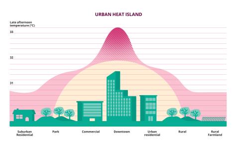
Buildings therefore constitute a source of heat at night that does not exist in the natural environment. There are also many other sources of heat due to human activity in cities, such as heating and air conditioning. All these factors explain the presence of a heat island in urban centres, resulting in a marked difference in temperature between the city and its surroundings, particularly at night. In Paris, for example, the average temperature in the city centre is 2.5°C higher than in the surrounding rural areas. The heat island is an effect of urbanisation that is of crucial importance in the current context of climate change, which is making heatwaves increasingly frequent and intense, and even more difficult to bear in urban areas. This is particularly the case at night, when cool refuges (air-conditioned centres, urban parks, etc.) are generally closed to the public, increasing the vulnerability of people who are already the most vulnerable.
Studying the climate of cities: measurements and modelling
The study of these urban microclimates requires a combination of real observations and computer modelling. To do this, Latmos uses data collected by the Site instrumental de recherche par télécommunication (Instrumental telecommunicationresearch site, Sirta) located near the École Polytechnique, in Palaiseau (Essonne). For over twenty years, this observatory has been collecting vertical profiles of temperatures, clouds and rainfall, using radar or laser remote sensing (lidar). In addition, the researchers are also using data from the Météo-France radar located in Trappes (Yvelines). Sophie Bastin explains: "Sirta's instruments look upwards, while the Trappes radar scans the horizon and produces data with a spatial resolution of a few kilometres." These datasets are also enhanced by data from the network of Météo-France stations, some of which are located in urban areas (in the Parc Montsouris in Paris, among others) and by additional measurement campaigns.
In addition to these measurements, new climate models are beginning to emerge that allow scientists to work on longer timescales, with better spatial resolution. "We've developed regional climate models that enable us to achieve spatial resolutions that are much finer than the global model used previously," the meteorologist explains. These models have the advantage of incorporating satellite data to take account of the specific characteristics of each city: the density and height of its buildings, the width of streets, the thermal capacity and conductivity of buildings. A city model (or urban pattern) is thus integrated into the climate model in order to best represent the effects of the city, its interaction with the environment and its atmospheric dynamics. In this way, it is possible to differentiate between a densely populated urban area, such as the centre of Paris, and suburban areas. Although these climate models do not simulate the temperature at street level, if the right parameters are used, they correctly reproduce the variability of the intensity of the urban heat island.
The CORDEX project, coordinated by the World Climate Research Project and inwhich Sophie Bastin and her team are taking part, is helping to make these models more complex. "The task involves determining what degree of complexity is needed to model the water cycle correctly in the city and its surroundings, while representing extremes, such as heat waves, at the climatic level." To answer this question, scientists from various international institutes run their models with more or less complex schemes and then compare the outputs with the measured data. If the model is right, it can be used to help cities adapt to climate change. With such a model, it's easy to reduce or increase human density, add parks, build or deconstruct an area of the city, and monitor the effects these measures will have on precipitation or heat waves, all in the context of a global climate that is heating up.
InteGREEN: understanding the advantages and disadvantages of urban vegetation
Increasing vegetation in cities is often seen as a good way of adapting these environments to climate change and making them more habitable. Plants improve the health and well-being of residents, while reducing the local urban heat island and the risk of flooding. However, this vegetation is itself sometimes a source of air pollution and can cause problems in the distribution of water resources.
The goal of the InteGREEN project, launched in April 2025 as part of the PEPR (Priority Research Programmes and Equipments) Sustainable Cities programme, aims to evaluate as thoroughly as possible (in terms of climate, water resources, air quality, sociological aspects,etc.) the urban services provided by plants, taking into account both their benefits and their undesirable effects. This interdisciplinary study then aims to help cities plan their green spaces, showing them which species to plant and where to position them. Sophie Bastin and her team are involved in the project and will be using their climate models to understand the impact of vegetation on the water cycle (temperature, clouds, rainfall, etc.)
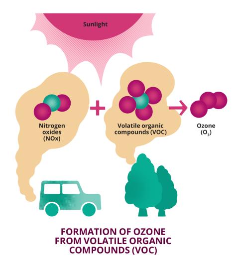
Another team from Université Paris-Saclay is also involved in the project: Valérie Gros's team from the Laboratory for Climate and Environmental Sciences (LSCE - Univ. Paris-Saclay/UVSQ/CNRS/French Alternative Energies and Atomic Energy Commission, CEA). Specialising inexperimental atmospheric chemistry, this team operates the station on the École Polytechnique site, which is part of Sirta and which scientists use to measure the concentrations of certain pollutants in situ. While Valérie Gros is interested in “classic” reagents such as benzene, which almost exclusively come from human activities, she is also studying volatile organic compounds (VOCs) produced by vegetation, such as the terpenes that give pine trees their distinctive scent.
While these compounds pose no problem in natural environments such as forests, the situation is quite different in urban environments, where they mix with human-made pollutants such as nitrogen oxide emitted by cars. "VOCs are highly reactive compounds which, through chemical reactions, are transformed in the atmosphere, producing secondary pollutants such as ozone or organic aerosols," explains Valérie Gros who, as part of the InteGREEN project, is working with her team to determine which tree species produce the least VOCs, and under what conditions. Conducted in close collaboration with decision-making bodies such as the City of Paris and the Greater Paris Metropolis, the project also involves institutions such as Eau de Paris and AirParif, which manage the city's water and monitor its air, respectively. All the parties involved are hoping that the scientific findings of the project will soon lead to practical applications for the research.
VOC emissions from trees: a source of secondary pollutants
Valérie Gros and her team have already worked on the issue of VOCs produced by plants in the past. As part of the STREET project (Impact of stress on urban trees andon city air quality), they carried out measurements in Vitry-sur-Seine and then in Paris during the spring-summer periods from 2020 to 2022. The aim was to quantify the impact of urban trees on air quality. "We first measured VOC emissions from fourteen small potted plane trees. Wethen took measurements in more real-life conditions, using a small park near the Hôtel de Ville as the subject of our study, chosen for its variety of plant species and proximity to the banks of the Seine, a major source of pollutants from human activity," the researcher explains. As different tree species secrete different families of VOCs, in disparate quantities, studying a park with a variety of trees helps us to understand which tree species are least likely to be a source of secondary pollutants, and therefore the best to plant in the city.
To measure the secretion of VOCs by the park's trees, LSCE scientists designed a chamber in which they enclosed one of the tree branches, then measured everything that entered and left the chamber. Once this data had been collected and the difference between the two has been analysed, the scientists cut the branch to determine its mass and relate the quantity of VOC emissions to the corresponding biomass. "Using all these measurements, we've been able to calculate the branch's emission factor," Valérie Gros highlights.
The researchers waited until summer to carry out their study, when solar radiation and heat are at their peak, as they are also known to promote the emission of VOCs. Ultimately, the scientists observed very high levels of VOCs, leading to greater production of organic aerosols. As the measurements had only been taken over the course of a month, and within a very local area, the STREET team then integrated them into a computer model to generalise the observations and make them more representative in time and space. The model also incorporated measurements made by the LSCE observatory, located on the Saclay plateau, which serve as a regional background. "On the Saclay plateau, when the winds come from the south-west, air pollution levels are very low because the air is coming from the ocean, having passed through very few urbanised areas," explains Valérie Gros.
Her team succeeded in quantifying the impact of trees on air quality on a city-widescale. They demonstrated that trees are responsible for a 5-10% increase in the concentration of secondary particles. Although integrating plants into air quality models is necessary, it is important to note that sources of pollutants from human activities are largely dominant in cities. And trees offer other benefits, such as a local reduction of urban heat islands. Studies like the one carried out as part ofthe STREET and InteGREEN project, help cities choose which plant species to grow taking air pollution into account.
Green roofs: offering benefits all year round
Trees aren't the only type of vegetation found in cities ‒ there are also plants, found in the form of green roofs. As these roofs are located high up, their effect on the heat island observed at street level is minimal. But indirectly, they improve the energy efficiency of the building on which they grow. "If we improve this energy efficiency, there's less heat transfer to the interior of the building. We release less heat from air-conditioning, thus reducing the heat island," explains Patrick Stella, lecturer at AgroParisTech and researcher at the Functional Ecology and Ecotoxicology of Agroecosystems laboratory (Ecosys - Univ.Paris-Saclay/AgroParisTech/INRAE). While the thermal insulation effect produced by green roofs is well known in summer conditions, it is just as important to understand what effect they have in winter, as there is a risk of them cooling the building.
Patrick Stella has been focusing on this issue, studying the roofs of the former AgroParisTech building on Claude Bernard street in Paris. "It's an old, poorly insulated Haussmann building with two green roofs: an extensive one (a thin layer of soil sparsely planted with sedums) and a semi-extensive one (a lawn)," the lecturer explains. At the same time, EcoSys scientists used a section of the roof not covered by vegetation as a reference. On each plot, they measured the temperature, heat transfer through the roof, and solar radiation. "Thanks to these observations, we have shown that green roofs do help to cool buildings in summer, but don't have the same effect in winter," says Patrick Stella. Adding a layer of soil and vegetation to the roof of a poorly insulated building can even reduce heat loss in winter.
Measuring and effectively reducing CO2 emissions in cities
While it is important to study the climate in cities to help them better adapt to climate change, it's also vital to monitor the impact of these urban areas on the climate. With this in mind, two LSCE teams are participating in the European GHG monitoring infrastructure, ICOS (Integrated Carbon Observatory System). They manage some forty carbon dioxide (CO2) measurement points spread across Greater Paris, an urban network with a density unmatched by any other in the world. Nine of the instruments used for measurements are extremely precise. "They are the backbone of the network. We then wanted to increase the density of measurement points in this urban environment, so to do that we added more, but less accurate, observatories, "Michel Ramonet and Olivier Laurent explain, both LSCE researchers involved in ICOS.
These measuring instruments are installed on the rooftops of Paris, keeping them away from traffic and enabling measurements to be taken over a widerarea. CO2 measurements, coupled with atmospheric transport models, validate or clarify statistical inventories. This is a method of estimating CO2 emissions by adding together various known sources. "These are collections of activity data. For example, we count the number of cars that pass on a road, and we collect data on energy or heating usage," adds Michel Ramonet. Statistical inventories, carried out by AirParif, are compared with actual measurements to ensure that none of the sources have been overlooked or underestimated. "Although trends are the same, the measuring points are always higher than statistical inventories. So, we believe that these inventories underestimate emissions," the researchers conclude.
As part of ICOS, the two LSCE teams are involved in another project, ICOS Cities, which aims to establish a standardised methodology for measuring GHGs in cities. With many European cities aiming for carbon neutrality by 2050, it is becoming necessary to reliably assess their CO2 levels and monitor emission trends quickly after anti-pollution measures have been put in place. Using three European cities of different sizes – Paris (France), Zurich (Switzerland) and Munich (Germany) – as examples, ICOS Cities aims to help cities that so wish to set up measuring instruments that are standardised at a European or even global level. The scientists are also aiming to provide them with recommendations on best practices for monitoring CO2 emissions.
By working to better understand the dynamics of urban climates, scientists hope to identify levers for action to support them in developing urban planning decisions, helping cities better adapt to climate change and improve the living conditions for their inhabitants. The hope is to build cities that are both carbon neutral and pleasant to live in.
References :
- G. S. Langendijk et al. Towards better understanding the urban environment and its interactions with regional climate change - The WCRP CORDEX Flagship Pilot Study URB-RCC. Urban Climate, 2024, 58.
- L. Sangelantoni et al. Investigating the representation of heatwaves from an ensemble of km-scale regional climate simulations within CORDEX-FPS convection. Climate Dynamics, 2024, 62.
- A. Maison et al. Contrasting effects of urban trees on air quality: From the aerodynamic effects in streets to impacts of biogenic emissions in cities. Science of the Total Environment, 2024, 946.
- P. Stella et E. Personne, Effects of conventional, extensive and semi-intensive green roofs on building conductive heat fluxes and surface temperatures in winter in Paris, Building and Environment, 2021, 205.

This article was originally published in L'Édition n°27.
Find out more about the journal in digital version here and on Calameo.
For more articles and topics, subscribe to L'Édition and receive future issues: